Showing posts with label coast. Show all posts

Friday, 14 November 2014

Quintessentially English

Capstone, Ilfracombe, water, sea, cliffs, grass, sky, statue, coast
Atop the Captsone
A few weeks ago I had the absolute pleasure of giving a friend away. No, not at some sort of charity car boot sale; it was at her wedding. She had had the good judgement to get married at Tunnels Beaches in Ilfracombe, Devon. Not only is it a fantastic venue in which to get married with views out to the Irish Sea and your very own private beach to explore, but the town of Ilfracombe itself is a very picturesque one. Having spent 6 hours on a coach getting there after work I was keen to get out and about the next morning. As luck would have it my hotel was just opposite the Capstone, as locals call it, or as you and I might, the big cliff thing.

church, silhouette, sky, spire, clouds,

Freshly fueled with eggs and bacon I charged up to the top as fast as my little legs could carry me where, at the summit, I was rewarded by fantastic views in all directions. To east and west were views of the coast and cliffs, and to the south all of Ilfracombe was laid out before me. The terrain is hilly and the bulk of the older part of town nestles in a valley running parallel with the coastline; some newer developments have followed the valley as it kinks south. Very little land is wasted, the hills are steep and so many streets are terraced, clinging to the sides of the slopes as the terrain permits. The result is lots of little blind corners, narrow alleys and sudden inclines that frequently put me in mind of the time I spent in south Wales as a child; which shouldn't be so surprising given the two are only separated by 30km or so of water. Indeed, the hotel played Welsh radio in the dining room, which rather threw me as I hadn't undergone the normal mental preparation I would customarily go through before returning there. Also at the peak was the statue in my photo at the top of this post, although I'm afraid I must confess that I have no memory of why it is there or what it represents. I can say that it does a good job of conveying the energy and movement that is so evident atop the cliffs there.

Landmark theatre, Ilfracombe, water, sea, sky, coast, hills, cliffs
The Landmark Theatre, at bottom left, tends to polarise locals; they either love it or hate it.
My time in Ilfracombe was short but very pleasant. I have been to that part of Devon before and will happily return again in the fullness of time. I don't get to the coast as half as much as I would like which is a shame because the UK is blessed with hundreds of miles of beautiful coastline. I must make sure I don't neglect it so in the future.

Sunday, 14 October 2012

Reykjavik


Reykjavik, harbour, Iceland, sky, sea, mountain, cloud, sculpture, reflection, mount Esja, Faxafloi
The reflection underneath is a bit spidery for my liking.....
Takk. That's how you say thanks in Icelandic; nice and easy. Every other word in the language, every single other word, is completely unpronounceable. You might be forgiven for thinking that there would be some slight similarities between Icelandic and English, they both have a solid Norwegian base to them from when  our two islands were colonised by the vikings in the last half of the first millennium; but you would be wrong. Very wrong. Icelandic is actually more like ancient Norse than modern day Norse is; due to centuries of isolation and a policy of actively coming up with words with an Icelandic root instead of borrowing from other languages it has evolved very little. As examples of the way they police their language: their word for computer translates as number prophetess; telephone is long thread; mobile phone is travelling long thread; and, rather worryingly, they have no word for interesting. To hear Icelandic spoken is, however, quite interesting. It has a fairly quiet and reserved tone to it, as do the people in general, but every now and then, out of no where, they throw in an exaggerated ook sort of a noise as if they're trying to out honk one of the local geese that populate the area in place of the pigeons you normally find in most cities. Imagine a drunk Welshman doing a Monty Python impression and you might be half way there.

Names, of people, are also a little unusual. Similarly to Russian they have a patronymic and matronymic system; basically you come up with a forename for your new son but his surname is already decided - it's his mother's name with son added onto it. Concordantly, the surname for a girl is her father's name followed by the Icelandic for daughter, dottir. To clarify, I would be called Jason Pearlsson, my wife would be called Susan Davidsdottir and SKY news correspondent Kay Burley would be Kay Satansdottir. Simple.

So it was that Sue Davidsdottir and I set off into this alien culture with aspirations of whale watching and a good view of the aurora borealis; sadly, we would only achieve one of these.

Reykjavik, harbour, Iceland, sky, sea, mountain, cloud, sculpture, reflection, mount Esja, Faxafloi

Reykjavik was first settled by Norse colonists in the year 870 and was called such because you can just about make out steam from nearby hot springs (Reykjavik means Smokey Harbour); the city, indeed the country, was mostly just a fishing and sheep farming outpost for the next several centuries and when the city received its charter from their Danish rulers in 1752 the population had grown to a colossal 167 individuals. The charter wasn't granted to the people themselves or some sort of mayor or ruler but to a corporation that was tasked with developing native industries with a view to improving living conditions of the indigenous population. Today there are 120,000 people in the city and 320,000 in the country as a whole and they are free to enjoy what is widely acknowledged to be amongst the best healthcare and educational systems in the world. This is probably in no small part due to the fact that 80% of the tax collected in Iceland is spent on those two areas alone. This, combined with the fact that they have no standing army, 100% of their power comes from geothermal or hydroelectric sources and a few other key indicators, has led to Iceland being rated the most peaceful country on Earth.

Reykjavik, Iceland, Tjomin, lake, sky, town houses,
The most built up area in all Iceland; some of those buildings are as many as four storeys high!
Despite being the largest city in Iceland by quite some distance Reykjavik has maintained the feel of a sleepy fishing town. The picture above is from the top of the Hallgrimskirkja cathedral looking west towards the harbour over the most developed part of the city but it looks more like a leafy suburb. As they have chosen not to build upwards it does mean that the urban sprawl continues for some miles east and south and is beginning to swallow up what used to be smaller satellite towns in the same way that Copenhagen and Oslo have done.

The panorama below is of the far side of lake Tjomin which nuzzles up against the side of the Icelandic parliament thAlþingi, pronounced AL-thing, the oldest parliament in the world at well over 1,000 years old. I like the contrast in the leaves of the trees as they begin their journey from green to brown through yellow and red. It also nicely highlights the degree of variation that is to be found in Icelandic architecture; it's quite unusual to find two buildings next to each other that are the same and this makes walking the streets of the capital all the more interesting. This is in stark contrast to the unrelenting tedium of new, suburban developments in the UK where conformity seems to be the order of the day.

Reykjavik, Iceland, sky, lake, cloud, panorama, trees, autumn


I really liked Iceland. As soon as I stepped off of the plane and saw the bleak, rugged landscape and felt the icy wind bite I knew that I was going to enjoy this rough, harsh country. When I go on holiday I prefer to see mountains and ice over sun and sand; I like to feel that at any moment the weather could turn and you'll be hit with a storm that makes even getting something to eat an ordeal. This is just as well, because this is what we got. Our first day was wet, cold and blustery; pretty bad weather-wise. From bad it turned to brutal as winds reached gale force and the rain got heavier and heavier so whilst I enjoyed doing battle with Iceland and its weather it did mean that photography opportunities were few and far between, not if I wanted my camera to avoid a soaking in any case.

In my next post I'll describe the trials and tribulations of sightseeing in a country that is the second most volcanic in the world and sat between two of the roughest oceans we have. For now I'll say that there was a brief moment of respite; for two hours on our final morning in Reykjavik the rain stopped, the wind dropped  and the clouds parted. For two hours the sun shone through and gave me some of the most beautiful, crystal clear light I have ever seen. When I saw how things had improved I instigated a desperate rush around the city revisiting the key landmarks that we had been perusing under much less favourable conditions for the last few days. Even though it was almost noon the sun was still very low in the sky as we were only a degree or so from the Arctic circle. For the shots of Mount Esja and the Sun Voyager sculpture the light also happened to be coming in from the side and so was perfect for giving depth to the mountains. I am very happy with the panorama below, it is well worth looking at on a big screen and I foresee a canvas print of it on my living room wall in the not too distant future.


Reykjavik, harbour, Iceland, sky, sea, mountain, cloud, panorama, Faxafloi, Mount Esja
Click to enpanaramatudinate


Sunday, 9 September 2012

Pelicans

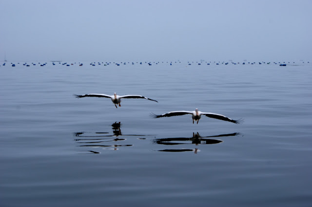
Namibia, Swakopmund, pelicans, cape seals
The blue buoys in the background are markers for an oyster farm

Here is a set of images I took nearly three years ago now of a pair of pelicans coming in to land. My wife and I were in a small boat off the coast of Swakopmund, Namibia and the pelicans knew that if they came and said hello they would be rewarded with a few choice mackerel. Taken together the three images give a great sense of the grace and control these birds have as they come in to land, but, we almost missed the opportunity all together....

Namibia, Swakopmund, pelicans, cape seals

The town of Swakopmund, (one of my favourite place names of all time, right up there with Saqsayhuaman and Fingringhoe) can be found about half way up Namibia's long Atlantic coast line almost directly west of the capital Windhoek. It's a curious little town, a bit like, I imagine, stepping back into 1970s East Germany. Not in a Stasi, Eastern Bloc kind of way but in a way that brought to mind what Germany might have been like without the burden of mass industry and high technology. You see, during the Scramble for Africa we got South Africa, Egypt, the Sudan and others; Belgium got what is now the DRC; the French got much of the north west of the continent and Germany got a portion down in the south west of Africa which they called, with typical Teutonic imagination, German South West Africa, now known as Namibia. The result of this was a little slice of Bavaria in the desert on the opposite side of the world.

Streets in Swakopmund have names like Nord Ring, Heuschneider and Mittel Straße and it couldn't be easier to find a cold, European style beer and a stein to drink it out of. Nationally, one third of white Namibians speak German and this proportion is thought to be higher still in Swakopmund. So, pretty German, then. It was for this reason that we were rather worried that we were going to miss our boat trip as Germans don't tend to be keen on tardyness. You see, we were under the impression that we were going to be picked up from our awesome accommodation and taken the 20 miles or so down to Walvis Bay where the trip began; but more than 20 minutes after we expected to be picked up we found out that we were going to have to make our own way there and average a mile per minute in the process. We were on a driving holiday, doing a lap of Namibia and so we had our own wheels but this was still less than ideal. We covered thousands of kilometres on that holiday and more than 90% of it was on gravel roads; luckily this little stretch was 100% lovely black top.

Namibia, Swakopmund, pelicans, cape seals

With Sue doing her best Jensen Button impression we made it. Just. But it cost us some light ribbing from the boat load of middle aged German tourists that seemed to punctuate our way around the country, Namibia being quite a popular tourist destination for our Germanic cousins. The main point of the trip was to see the enormous Cape Cross seal colony and, if we were lucky, dolphins; we knew the pelicans would be there but we didn't give them much thought. As we saw them come gliding into view though, through the early morning mist over a perfectly still Atlantic, they had an undeniable majesty to them that let me easily capture a great little series of images.

Another highlight was when a, presumably semi-tame and well rehearsed, male seal climbed up the back of the boat and onto the deck. Now, we were not on a large boat, she was only about 20 feet from bow to stern so to have a 9 foot seal weighing a third of a ton lumbering about was, I admit, a little disquieting. All of a suddenall the human cargo had to pin themselves to the side railings to give this behemoth room to, well, generally stink the place up. If I'm honest, my lasting impression of this encounter nearly three years on, once you've got used to the enormous size and very pointy looking teeth, is that seals really, really stink of fish. I guess he was quite cute in his own way, and he certainly seemed to appreciate his free breakfast.

The last picture I'm going to show you from this trip was one I caught on the fly, so to speak. It still cracks me up every time I see it. I would say that this shows pelicans looking slightly less graceful than in the previous photos and if you look carefully you can just about see a fish below it's beak that had been thrown for it to catch.


Monday, 7 May 2012

Tulum


tulum, mexico, coast, yucatan, ruins, beach, sky, maya, paradise

It's pronounced TOO-lum. No, I hadn't heard of it either. Nice place, though; you can find it in the Yucatan peninsula on the west coast of Mexico. About half way between Cancun and the border with Belize lies this most unusual, not to mention beautiful, of sites. As you can see from the picture below it is quite popular with the tourists and this is by no means a new phenomenon established by the gringos. This was a coastal retreat of Mayan kings in the 13th century, and who could blame them. I mean look it. I have read many books on pre-Colombian America, I have watched many documentaries about it and I have scoured every last inch of the British Museum's Mexico gallery but I had never come across this jewel of a location and we basically decided we were going to come here on the strength of pictures just like these. Having arrived at Cancun airport, then, we hopped onto a couple of buses and got ourselves down the coast arriving slightly after dark.

Fancy a visit?
Perhaps the reason that I hadn't come across Tulum was that, by Mayan standards and Mesoamerican civilisations in general, it's not a particularly important place. The buildings are quite small and they were mostly built at a time when the once great Mayan empire was in decline. There are no grand pyramids like at Chichen Itza or Teotihuacan; it wasn't a permanent seat of power like Yaxchilan or Palenque, and it's not in a geographically significant position like Tenochtitlan, now Mexico City. Yet it's position is, essentially, why it exists at all. The main building complex straddles two headlands that form a cove about 100 yards wide. The volcanic basalt cliffs embrace the golden sands as if to protect them from the unknown dangers of the deep. An arrow shot from the shore there is a coral reef, the second largest in the world, that, viewed from the cliff tops, tantalisingly breaks the water's surface between the gentle white waves. This reef perhaps gives a hint as to the first function of the site; it may well have acted as a lighthouse and, indeed, there is growing archaeological evidence to suggest just that. The main building of the complex, known as El Castillo, has a novel and sophisticated lighting system that would have allowed navigation of the narrow channel between the reef and the cliffs. So Tulum was once a port that was soon appropriated by the ruling class of the time and so began it's long history as a tourist resort.

It is about a kilometre walk from the road that runs through the town of Tulum, often referred to simply as Pueblo, to the ruins on the coast. A wide gravel path has been hacked out of the jungle to allow access and as we made our way down it the heat and humidity became ever more oppressive. 35C and 95% humidity does not lend itself to so much as a gentle stroll much less lugging a heavy camera bag up and down hills. To protect the trade that went through the port the three landward sides of the complex were surrounded by a very large, very think stone wall through which two breaches have now been made on the north and south sides for the passage of tourists. This wall was 4 metres high, 8 thick, ran for over 700 metres and would have been an incredible undertaking which gives some measure of how important a trade route this was considered at the time.

tulum, mexico, coast, yucatan, ruins, sky, maya
This photo nicely sums up the Mexican attitude to polite notices
As the port grew in importance this inevitably attracted a larger and more diverse set of people to the area and soon a town of more than 1,000 inhabitants had been born. More and more structures were built, residences, a commercial area; an observatory (the Mayans were accomplished astronomers and mathematicians, temples for worshipping in; and so it was that, in 1518, when Juan de Grijalva saw this mass of structures all painted red, blue and white atop the cliffs from his boat he declared that he had found the Seville of the New World. Anyone that visits Tulum will know that this is a gross exaggeration but it would still have been an imposing sight. Grijalva was leading a small expedition from Cuba under the instructions of  the legendary Hernan Cortes who had set up a base from which to explore the New World; it would be he and his men that would conquer the Aztecs who controlled the interior of Mexico over the next few years.

Tulum was not put under siege or fought over with the invaders, the fall of this city was a gradual one caused by the breakdown of society that occurred as European diseases swept through the continent and decimated populations. Within 70 years of Europeans landing in the area Tulum had been abandoned to the jungle; it's only permanent residents now being the hundreds of black lizards 1-3 feet long that sun themselves on the exposed rocks. It wasn't until the first decades of the 20th century that it was put back on the map as archaelogists slowly revealed it's secrets.

All of the places and people I have mentioned in this blog will have their stories revealed over the next weeks and months. Everyone has heard of the Aztecs but not many people know the remarkable story of the collapse of this awesome empire at the hands of just a few hundred ruthless men. This was our very first port of call in Mexico and whilst, perhaps, the structures themselves were not the grandest or largest that we would see we could not have hoped for a more tranquil and beautiful beginning to our travels.

tulum, mexico, coast, yucatan, ruins, beach, sky, maya, paradise

Wednesday, 9 November 2011

The Bay of the Descending Dragon

I think I'm going to find this post difficult to write, partly because I don't particularly like the photos I took of the area and partly because I'm in serious danger of sounding like that most awful of things: a travel snob. I'll do my best to avoid this, I'll try to explain my misgivings in a fairly neutral manner, if it reads back as snobbish, then so be it. But I'll build to that......


The Bay of the Descending Dragon, then, is the translation of Ha Long Bay, that place I had so long wanted to visit. It can be found, here, about 100 miles from the capital, Hanoi. Over the course of 75 miles there are approximately 3,000 limestone islands that abruptly jut out of the sea in a way that I have always found captivating. The bay was recognised by UNESCO as a World Heritage Site in the mid '90s and has risen steadily up the list of 'Must Sees' on the average tourist's itinerary ever since. Some of the islands are very small and just a few hundred square metres in size whilst the largest, Cat Ba, is more like 150 square kilometres. One thing they have in common is that they are all smothered in fairly dense tree cover that, on the larger islands, is diverse enough to support quite a broad range of fauna. There are various goat type animals and some more exotic ones like Golden Headed Langursrhesus macaques and even some leopard cats. Research reveals that the islands were formed as a limestone plateau slowly sunk down and collapsed over millions of years; what made certain clumps remain standing proud I have no idea.

Although the area has very little habitable land it does, nonetheless, sustain a community that can trace it's ancestry back over millennia. Today, their traditional way of life has, depending on your viewpoint, adapted/become threatened by the influx of modern tourism. Living their entire lives on a series of boats and pontoons all lashed together they used to survive by fishing and exchanging their catch for land-based commodities. Nowadays they instead survive by providing kayaking opportunities to the glut of tourists that flow through the area.

A rare glimpse of blue sky

It takes a long time to learn your way around Ha Long Bay, to know which channels are deep enough for your vessel, which flow the way you want them to and so on, and this has often led to it being a stronghold of resistance from foreign invasion be it by the United States, who heavily mined the area leaving some parts unsafe even to this day, or the long term Vietnamese enemy, China. There is no love lost between these two countries, China has been trying to either occupy or exert it's influence over Vietnam for thousands of years. Earlier this year China was to be found pushing the bounds of Vietnam's sovereignty and in the news whilst we were there there were stories about China chancing it's arm by occupying a small, resource-rich island in the South China Sea that belongs to Vietnam. In the late 13th century Ha Long Bay played an important role in the expulsion of the great Northern Enemy from it's territories. Then it was in the form of the armies of the famous Kublai Khan, grandson of the infamous Genghis Khan, that had invaded. The locals of Ha Long Bay drove massive bamboo spikes into the seabed just below the surface and then forced the enemy vessels onto them sewing panic and confusion into the fleet and opening them up to defeat.

Not our boat, but they were all very similar to this

At that time Vietnam was known as Dai Viet and only extended as far south as what is currently thought of as central Vietnam; the south being occupied by the Champa people of My Son fame that I talked about in a previous post. It was many years later that the Vietnam we might recognise today came into being by incorporating the region to the south as the Champa moved out. Indeed, the word Vietnam means Viet - people, Nam - south; People of the South. This doesn't specifically refer to the south of Vietnam but is more a way of delineating itself from the Enemy of the North, China and Mongolia. As an aside, Vietnam should actually be written in two words: Viet Nam. In fact many of the words that the west uses should be two or more; Ha Noi, Sai Gon, Da Lat, Dien Bin Phu. The contractions of these words only came about in western circles as reports started coming back from the front line as the French and then Americans went to war there. The journalists used the Telex system to file their reports and this charged by the word so they just contracted some words to save money. There is talk of a move to make an effort to resort back to original spellings but some officials are reticent to upset or confuse potential foreign investors.

But now I'm rambling, back to the Bay, and then my gripe.....


One thing I didn't know about Ha Long Bay before I got there was that it has masses of caves. We had about 20-30 minutes in one of these caves, The Cave of Marvels (so named by 19th century French tourists), and I got some interesting photos whilst I was in there. The photos look quite bright but that's because the exposures are all in the region of 6 seconds or so; luckily I had thought to take my trusty tripod with me. Although they add some unusual colours to the photos it was a bit off putting to see the caves lit up by so many multi-coloured lights. It leant an air of Disney-style tackiness to the set up which was more of a distraction than an enhancement. Also, when I say we had maybe 30 minutes in there that's probably being generous. We were all but marched through with a couple of hundred other tourists and I can't help but feel that this was not the best way to contemplate the endless millennia that had gone into creating such mesmerising formations. And so begins my moan.

Almost everything in this blog post that resembles a fact or useful piece of information about Ha Long Bay and it's caves I got from the hours of research I do before starting a post like this. It probably takes me 3-6 hours on average to come up with a wordy post like this one, each fact I come up with I try to verify from a second source - and I never use Wikipedia. Normally I take the info I gleaned from tour guides or local people, try to verify it somewhere and then write it up. In this case the only thing I learnt from the tour guide or anyone in the vicinity was that the monolithic outcrops were made from limestone, but I spotted that as soon as we landed on one. Pollution is known to be an increasing problem in the Ha Long Bay area, the water was pretty filthy anywhere near a shoreline from both the diesel engines that power their boats and from their day to day refuse; locals tend to just throw their rubbish into the water. This might not have been a problem when all they were throwing overboard was food scraps and bamboo, but when it's countless pieces of plastic then the problem builds rapidly. This was indicative of the general attitude that seemed to permeate the region; the locals didn't seem to care about this amazing place in which they lived and that fed through to the tourist experience. They didn't provide any information about the area, didn't explain it's rich history, didn't tell us anything about their culture, they didn't make you feel at all welcome; it was like they had heard that tourism was just where you cram as many white people as you can into an area and charge as much as you think you can get away with for the privilege. Well, it's not. There was a cynicism here that I'm more used to seeing in the East End of London.


Part of the Cave of Marvels

I suppose this is where I could be sounding awful. It's easy for me to bemoan the behaviour of people that don't have the wealth and opportunities that I do, people who have to put all their effort into scraping enough money together to feed themselves and eke a living as best they can. But, then, I've been to a lot of places around the world that are far poorer and in far worse shape and don't have such a wonderful natural resource to exploit and yet the local people are still proud of what they do have and they take pleasure in being able to show off this precious commodity. And I don't mind being exploited myself, it's to be expected; I almost always over tip and pay over the odds for things but I'm happy to do so, they need it more than I do. But there was no care, there was no love, there was no respect for their own home; it was just a conveyor belt of tourists. Personally, I think you can take heart in your surroundings no matter where you live and if you can instill a sense of civic pride that permeates a community then those that visit that community will step in line and offer it a similar level of respect.

There are many examples around the world where this careful balance has been achieved, the one that sticks in my mind is that of the Inca Trail to Machu Picchu (see my post on it here). For many years the trail was a free-for-all. Dozens of companies existed to take tourists to this most enchanting of places but there was nothing to say how many they might take, how many tourists per guide there should be, how much to pay the porters or how heavy a bundle the porters have to carry; also, it was becoming clear that the monument and indeed the trail itself was suffering with such a high rate of traffic. But then the Government started taking notice and they put a cap on the number of people allowed in each day, insisted on minimum standards of safety (still quite perilous by Western standards), decreed that the trail would close entirely for one month in the year for cleaning and restoration work and, importantly, a maximum weight and minimum wage was introduced for the amazing porters that do all the hard work and make the whole project run so seamlessly. In fact, I've just had a quick look and the authorities there have made the regulations even more stringent just this summer, there are now only 2,500 visitors per day allowed in to Machu Picchu. Now, this restriction of tourists may have meant less money incoming for local people, but that hasn't happened as the price has risen considerably over the years. Machu Picchu is preserved and local people can still earn a living, it's a good system that works well.


Personally I still found the actual geography and geology of the region very beautiful and worthwhile seeing; although I know that not all of my companions felt similarly. The final nail in the coffin may well have been when they tried to get everyone involved in an evening's karaoke - this was not what we were there to do and, it being a small boat, there weren't many places to hide. The only other event that was laid on was when they pulled up the boat's cook from below decks who showed us how to make spring rolls and then got us to make our own. This was a very simple and cheap way of involving us in something a little more personal and went down very well.

So ends my rant. I was right; I didn't enjoy writing this. I've never written negatively about anywhere I've gone before but, then, generally I always enjoy myself because the local people do such a good job often with very limited means. Soaring mountains, crystal clear lakes, expansive deserts or vast savannas are all well and good, but it's people that really make a place come alive. Hopefully I haven't come across too terribly, but I think I have a point in there somewhere. You can judge.


Monday, 24 October 2011

Vietnam

Vietnam, then. It's quite a country. The first country I've gone too in Asia and, based on my experiences there, hopefully not the last. We started by arriving in the capital, Hanoi, in the north of the country; a frenetic, hustle and bustle type of place where crossing the road is a genuinely exciting endeavour. The older part of the city is full of narrow, twisting streets where if a bar runs out of room to seat it's guests it simply starts putting them out in the road, even if that means restricting flow to one lane - not that vehicles stick to any given lane.

One of Hanoi's more open and less busy streets


From Hanoi we moved on to Ha Long Bay, a place I had wanted to visit for many years. Sadly it was cloudy nearly the whole time we were there but I still enjoyed seeing this most unusual of seascapes. Vast outcrops of limestone soar out of the sea in a seemingly random manner; carpeted in trees and without any apparent flat areas they take on an ethereal aspect, especially in the early morning haze.


From Ha Long bay we moved on to Hue (pronounced Hway, possibly. See below) which is famed for it's Imperial City. Formerly a capital of it's country, I'm afraid to say that by the time we got this far I had all but given up on trying to learn Vietnamese. I normally pride myself on learning, at the very least, how to say hello, goodbye, please and thank you in any given language but, like many oriental languages, Vietnamese is tonal. This means that even if you figure out how the word should be pronounced, which is hard enough, the tone in which you say it can completely change it's meaning. For example, the word ba, I had looked it up as it is the word for Mrs/Madam. Can't be too complicated, can it? Two letters, and both of them pronounced how you might expect. However, each vowel in Vietnamese can be said with up to 6 different tones; mid-level, low falling, high rising, and so on. Each of these tones confers a different meaning to the word. Ba, then, depending on what tone you say it in can indeed mean Mrs, or it can mean three, grandmother, aunt, any, waste or poisoned food. Interact at your peril. Most people looked at me with a puzzled look, some with amusement and some mercifully came to my rescue with vastly superior English. I found Arabic easier than this; Vietnamese totally defeated me.

Statue and pagoda in Hue's Imperial City
Hue gave way to Hoi An, probably the most traditionally picturesque town we stayed in. Hoi An is renowned for it's tailoring industry; every third or fourth shop is a tailors and their rates are invariably very good. Walk into their shop and they will offer you a range of everyday western catalogues like the Next Directory, all you have to do is pick out what you want and they will make it to measure; in less than 24 hours. My wife got shirts, skirts and a jacket for about seventy pounds. Bargain. Furthermore, they'll hold onto your details for you so, so long as you don't change shape too much, you can e-mail in an order at a later date and have them ship it over to you; all of which is far cheaper than the high street.

They were quite keen on lanterns in Hoi An
Based out of Hoi An we went on a trip to the My Son temple complex. Closely related to the larger and more well known complex of Ankor Wat in Cambodia, the My Son site was constantly occupied for 1,000 years. It was also home to a Viet Cong base during the war and therefore had holy hell pounded out of it by American B-52s; it is also recommended that you do not stray from the footpaths as the area is not yet fully cleared of land mines. Despite this, there is still lots left to inspire the imagination, as I suspect the designers of the Uncharted series may know.


An overnight train and a long bus ride brought us to our first stop in the south of the country, Da Lat. At 2,000m above sea level it had a very different feel to the rest of the country and the temperatures were mercifully lower.

The view en route to the Elephant waterfalls
Another hop skip and a jump brought us to Ho Chi Minh City, formerly known as Saigon but renamed in honour of their revolutionary leader. Ho Chi Minh City is actually larger than the capital, Hanoi, and, as it was mostly held by the Americans during the war, is generally more intact.

The moped - the workhorse of Vietnam
From there it is easy enough to go on an extended trip into the Mekong river delta. Here, the Mekong river sprawls out into a huge fan shape criss-crossing hundreds of miles with meandering water ways. Known as the rice bowl of Vietnam, it is the harnessing of this region that changed the country from a net importer of rice to the world's 4th largest exporter in just ten years.

Sue took this photo of the delta. It goes on like this for quite a long time.
This is just a taster of what I saw over the trip and I intend to write more detailed posts about each of these places and to tell the stories of some of the people I met over the coming months. I would just like to say thank you to all the people that helped make it run so smoothly and, of course, my travelling companions Sue and Eleanor for making it such a great trip.

Sunday, 11 September 2011

Porto

The Ponte Dom Luis, one of Porto's six bridges that cross the Douro

Porto is a curious sort of place. It has that juxtaposition of new and modern steel, glass and concrete against a core of centuries-old terracotta roofed buildings on a medieval street plan. It's an incongruence that many of Europe's oldest cities has to deal with and it's one of the reasons I generally prefer Old World cities to New World ones; they feel more organic, like they've grown with the need of their citizens as opposed to being artificially plonked down by a non-native explorer. I like the idea that when I'm walking down certain streets in London that there are over two millennia of footprints ahead of me to follow.

Like London, the development of Porto has been dominated by one major feature - its river. In this case, the Douro. Having gone on a little guided tour up and down it I learnt that it was only within the last 150 years that a bridge has been put across it; before that navigation was only possible by barge. There are now 6 bridges spanning the river that cuts it's way between the hills of this coastal region, one of which, no longer in use, was designed by a student of Gustave Eiffel.

Terracotta roofs on the south bank
Porto's south bank is dominated by an expanse of terracotta roofs the bulk of which belong to the still extensive Port cellars that produce over 8.5m bottles of the stuff each year; one of which sits proudly on the shelf behind me. This brings in over a third of a billion Euros to the region every year, little of which is apparently spent on the upkeep of their roofs.

Another mismatch I spotted was that dotted between the well preserved old buildings there were quite a lot of derelict ones. Strangely, though, they didn't look particularly out of place; if anything they actually added even more character to the place.

Nice occupied building

Nice derelict building

One particularly beautiful and well maintained building is Sao Bento train station. It looks more like an ancient bath house or museum piece but is still a fully functional station. The entrance hall is covered from floor to ceiling in ornate, hand painted tiles that depict scenes from the history of Portugal and landscapes too.


Porto has an array of long golden beaches which seem to have some good surf, which you might expect as Portugal bears the brunt of what the Atlantic can throw at it.


I really liked Porto, it felt welcoming, laid back, reserved and, down in the Old District, seemed to have a certain classiness about it. Although I was there for the best part of three days I don't fell that I really made the most of my time there, but that's probably because I went as part of a stag do as opposed to with my wife. For me, the highlight was walking across the Ponte Dom Luis; it gives enough height to afford a stunning panoramic view of the Old District that even my wide angle lens was struggling to capture at 10mm. With a clear blue sky overhead it was a rare treat.

Tuesday, 3 May 2011

Coity Castle, Aberdulais Falls and Southerndown

When visiting friends recently (thanks for a great time Rhys and Laura) my hosts were kind enough to specifically take us places where I could get the camera out, and very kind of them it was too. Whilst many of the urban landscapes of south Wales are bland, unimaginative, post-industrial horror stories (I'm looking at you, Port Talbot) the history and geography of the region is amongst the richest in Britain. In the 500 years after the Norman conquest there were few places in Europe that had more castles built in it than Wales; and whilst the reasons for having the castles there were rarely positive, today we are left with a wide array of the best medieval architecture available anywhere.

Many of these castles are now in various stages of ruin, of course, but I find that that often lends them a more mysterious and ethereal quality; it certainly doesn't make them any less photogenic.

coity castle wales ruins blue sky bridgend
Coity Castle
We did actually go to a post-industrial site on our first morning there, but in this instance the reason it was useful industrially was also why it was such an attractive place to visit - a series of waterfalls. A century ago Aberdulais Falls was the centre of a thriving tin processing industry, today it is a clean and pleasant niche in the rocks run by the National Trust. There are several natural falls there and at least a couple of man-made affairs that are more weir-like. When tin was being processed there, the difference in water levels was used to drive a water wheel which in turn was used to generate electricity, the largest such operation in Europe.

The falls provided me with another chance to practice with long exposures, although competing with the crowds meant I didn't have as long there as I'd have liked to. The photo below shows the main fall quite nicely; all the specks in the water also nicely show that I badly needed to clean my lens too.

aberdulais falls wales bridgend
Aberdulais Falls

Southerndown is a beach known to many in the area. It combines plenty of sand to lay on, lots of rocks to clamber over and investigate and impressive sedimentary cliffs from which to plummet. It used to be a regular day trip destination as a child but this must have been the first time I'd been there in well over a decade and it hadn't changed a bit - unlike my photo. Normally I don't like to mess with photos after I've taken them perhaps other than cropping out a lamp post or straightening a horizon; it's time consuming, boring and feels a little dishonest. It was a very dull and overcast day when we were there which left my picture of the cliffs rather underwhelming so I thought I would experiment with perking up the sky. While I still like the stepped nature of the cliffs themselves, this resulted in the sky becoming an odd aquamarine colour and the clouds just looking plain weird. I think in future I'll leave the special effects to those who know what they're doing.....

southerndown wales beach seascape landscape cliffs
The second beach at Southerndown